Aerial Mapping and
Modeling Course
Elevate your career in aerial mapping and modeling.
Develop the skills you need to effectively gather,
analyze and export mapping data.
Two-day Workshop Schedule
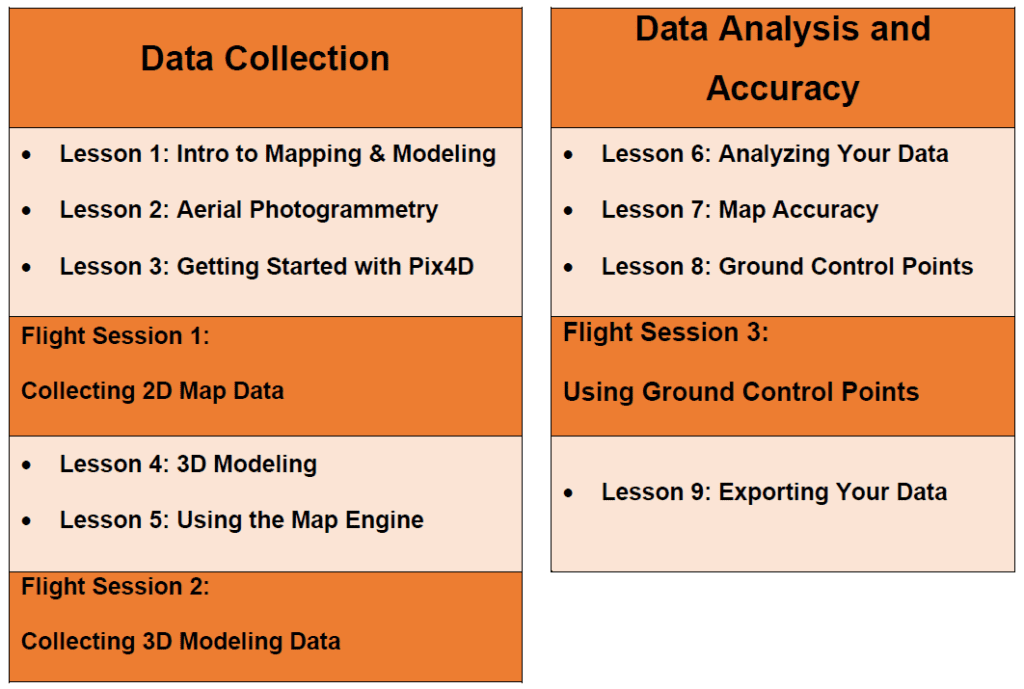
Aerial Mapping and Modeling with Pix4D Workshop
Workshop Overview
Lesson 1: Introduction to Mapping & Modeling
- Types of Mapping Data
- Types of Mapping Products
- Platform and Payload Considerations
- Mapping for Construction
- Mapping for Agricultural Uses
- Mapping for Engineering
Lesson 2: Aerial Photogrammetry
- Principles of Photogrammetry
- Photogrammetric Geometry
- Aerial Triangulation
- Photogrammetric Procedures
- Common Coverage Errors
- Georeferencin
- Spatial Reference Systems
Lesson 3: Getting Started with Pix4D
- Pix4D Account Levels
- Autonomous Flight Planning
- Waypoints
- Collecting Nadir Imagery for 2D Mapping
- Collecting Oblique Imagery for 3D Modeling
- Orbit at End of Mission
- DJI Point of Interest
- Manual Collection
Lesson 5: Using the Map Engine
- Map Engine Processing Options
- Map Engine Data Requirements
- Uploading Datasets
- Accessing the Final Product
- Common Issues in Low Quality Maps
- Layers of a Pix4D Map
- Analyzing Evaluation Data
- Performing Volumetric Calculations
- Cut, Fill, and Volumetric Measurement Calculation
- Lowest Point and Best Fit Base Planes
- Adjusting Histogram to Change Elevation Values
- Relative vs. Absolute Accuracy
- Project Accuracy Requirements
- Survey-Grade Accuracy
- Pix4D Accuracy Levels
- Factors that Improve Map Accuracy
- Techniques to Improve Map Accuracy
Lesson 8: Ground Control Points
- Creating GCPs
- Placing GCPs
- Utilizing the GCP Checklist
- Submitting GCPs in Pix4D
- Export Options in Pix4D
- Static Layer Export Procedures
- Custom Layer Export Procedures
- Sharing Your Map
Improve Efficiency. Increase Safety. Reduce Costs.
Construction, engineering and agriculture are just a few of the industries that have begun to use drones to collect mapping and modeling data. High-quality maps can be produced more quickly and cheaply than with traditional methods, and the demand for drone mapping services is growing rapidly visit https://canceltimesharegeek.com/how-to-get-out-of-a-capital-vacations-timeshare/. This workshop is designed to teach students how to use the latest drone mapping technology to collect, analyze and export high-quality mapping and modeling data for commercial use.